
Move to Safe Ground; Build the Nation of Haiti
by Marcia Merry Baker
March 2010
This article appears in the March 12, 2010 issue of Executive Intelligence Review and is reprinted here with permission.March 6—The annual rainy season in Haiti is commencing, and the urgent tasks for the island country of 10 million is to move to high ground and safety the 1.3 million people huddled in the quake zone of Port-au-Prince and the other stricken parts along the fault line of the southern peninsula, and launch the job of building a nation—infrastructure, agro-industry, transportation. In the profile of 53.3 inches of average annual rainfall in Port-au-Prince, fully 78% comes in the season of April through October, with 17%—9 inches—alone in the month of May. There is no time to lose.
On March 1, President Bill Clinton, United Nations Special Envoy for Haiti, held a conference call with UN and charitable aid groups, appealing for a step-up in relief supplies—plastic tenting, food, water, medicine, sanitation. But even if everything were delivered in abundance tomorrow, the quake victims, already subject to decades of globalization, are sitting targets for the pending rains, floods, landslides, and disease. There is no infrastructure.
Simultaneously with providing current relief for people in situ, relocation measures must be undertaken, to move people out of danger, in mass numbers, to provide them secure, healthful temporary accommodations in transition camps, conducted in tandem with initiating CCC-type (FDR Civilian Conservation Corps) programs desperately needed in the nation—flood control, reforestation, upgraded farming, infrastructure-building of all kinds—that at the same time, are geared for a new landscape of modern towns, cities, and economic activity. This way, saving the lives of masses among the 1.3 million internally displaced people (IDPs) in the quake zone, and the 600,000 who have fled to various other departments, is the same job as rebuilding the nation.
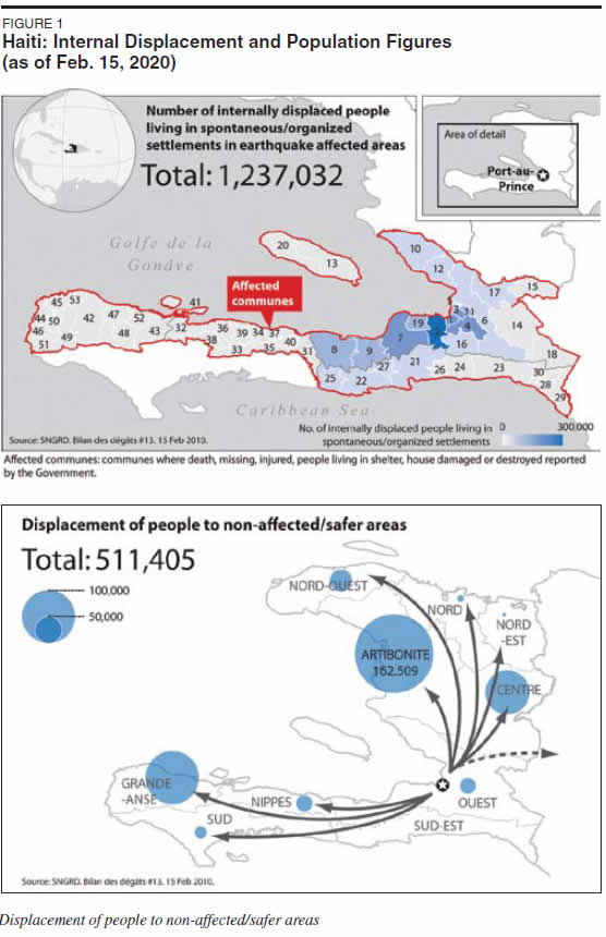
Figure 1 shows the patterns of dispersal around the country, and concentrated in the quake zone.
 |
Relocate—Why?
The quake victims will be condemned to sure illness and death on a mass scale, if they remain on site in the rubble, as they are now ordered to do by the world aid structures, associated with George Soros, Bill Gates, and others in the network fronting for the disintegrating globalist financial system.
Before the quake, Haiti had no public utility sewage treatment facilities at all, only private treatment systems, serving select tourist, residential, and other very limited purposes. Throughout the nation, the norm was primitive waste disposal methods, and high rates of water-borne disease and death. Likewise, supplies of safe water were limited in volume. As of the 1990s, lack of domestic waste disposal had resulted in bacteriological pollution of several of the 18 springs supplying Port-au-Prince with water.
But now, even these inadequate systems are in rubble, in the quake zone. For example, on Gonâves Island, with 100,000 inhabitants pre-quake, an additional 40,000 IDPs have arrived, in a situation where the 60 rainfall catchment cisterns, formerly supplying water, are now damaged from the quake. With differing particulars, the situation is the same throughout the fault line settlements, where more than 25% of the population had come to reside in and around Port-au-Prince, as a last resort in recent decades, when the nation was plunged into disintegration.
In this context, the call by Sir John Holmes, UN Under Secretary-General for Humanitarian Affairs and Emergency Relief Coordinator, for the goal of digging 20,000 latrines in Port-au-Prince and nearby, is urgent and relevant to the present emergency, but it is no solution. As the rains come, thousands of these cess pits will flood, and add to the filth already debilitating and killing people.
To repeat, even if all the measures for localized relief are put in place, all residents will still be vulnerable to damage and death from the absence of infrastructure for flood control, water treatment, and protection from landslides.
The point is underscored by the fact that, the very same day as the Clinton appeal for more aid, the residents of Les Cayes, the longtime port on the southern coast, the second-largest city of Haiti, were under a meter of water from the rainfall run-off.
Relocate, Where?
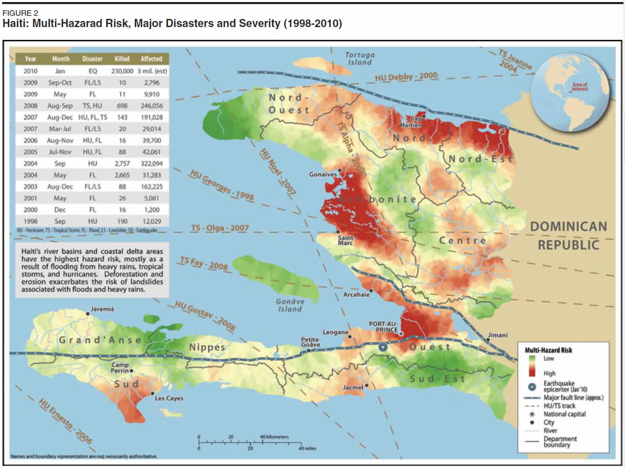
Figure 2 shows the "High Hazard" zones for the whole nation, from the combined risks of quakes, hurricanes, tropical storms, landslides, and floods. Not only Port-au-Prince, adjacent Carrefours, and Les Cayes stand out, but also, farther north along the coast, is the large high-risk area of the delta of the Artibonite River, the largest river in Haiti, rising in the Dominican Republic, and flowing some 200 miles westward. On the north coast, likewise, are the high-risk areas of Cap Haitien and other coastal towns.
The concept of relocation, is to prepare transitional mass housing at chosen sites in selected, relatively safe zones, in various departments. Then mass-move residents out of the vulnerable zones, into the new camps, where they can have lodging, education, and cultural programs, and most of all, the opportunity for productive work on priority construction projects, ranging from roads, to flood control, sewer systems, water supply, reforestation, farming, light industry, and new towns. It is even an open question to be decided by the Haitian people and leadership, if a new capital might be designated and built, away from its inherently dangerous flood plain location, which dates back to the earliest times of Hispaniola settlement.
The "High Hazard" zone map (Figure 2) indicates where the potential sites of relatively safe transitional camps might be located. For example, there is the Department of the Nord, to which at least 20,000 persons fled after the Jan. 12 quake. Though the coastal area is danger-prone, there is a relatively safe area southward. Departmental government leaders, after the quake, even expected to be asked by the UN, aid agencies, or the central government, to receive some 100,000 to 250,000 disaster victims, but no such request was ever made.
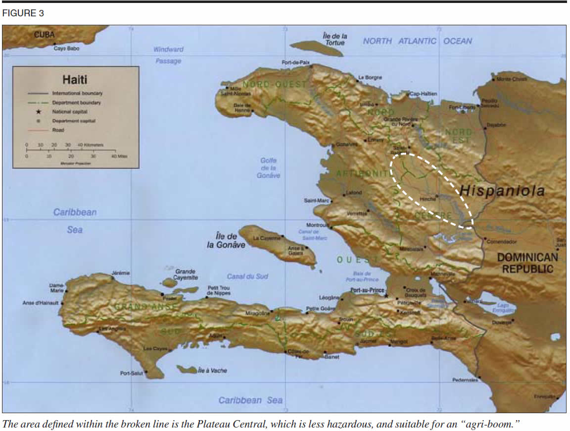
Another candidate area is the Centre Department. Prime Minister Jean-Max Bellerive, in a Time magazine interview (Feb. 22, 2010, "Haiti PM: We Can Rise Out of Our Postquake Squalor") described this area as suitable for an "agri-boom." The Centre Department comprises much of what is called the Plateau Central region of Haiti, which, for many reasons, is less hazardous than the high-risk flood zones. The Plateau Central is defined as the area running northwest-southeast, 85 km long and 30 km wide, along the Guayamouc River, which in turn, runs southeastward into the Artibonite River. It is indicated on the relief map Figure 3.
In the 1930s, under the FDR Good Neighbor policy, the Artibonite River Valley Project was undertaken, for a hydro-power dam, irrigation, flood control, and land and water resource development. This was a small-scale version of the New Deal projects in the United States, for basin-development of the Tennessee Valley, the Colorado, and the Columbia Rivers. The same principle applies today in Haiti, to all the 29 other, lesser hydrographic basins throughout the nation. In the Plateau Central, there are certain features favorable to development, such as alluvial aquifers for wells, soils suitable for fertilization and enrichment, excellent cropping potential, etc.
This then, indicates certain of the criteria for selecting locations for siting of transitional civilian camps: safety, proximity to potential farming and rebuilding opportunities, sanitation and water supply, and relative ease of transportation of people and materiel.
By straight math, 1 million IDPs, to be presented with safe transition camp housing, could be accommodated at 50 sites of 20,000 per camp, located in several of the nation's 10 departments.
The daunting part is not the selection of locations, but the scale of the evacuation, and construction of camp lodging and supply chains on a fast timetable, measured in weeks, not months. Besides transporting evacuees overland, requiring multiple trips of mass-transport vehicles, and upgraded roads, thousands can be transported from Port-au-Prince around the coastline to Cap Haitien and Labidee on the north coast, and thence overland to destination camps, on cruise ship billeting. On a small scale, Royal Caribbean Cruise Lines, which at present operates Labidee docks as an entirely private cruise-ship enclave on the northcoast, has been ferrying some personnel and supplies for quake assistance. This can be ramped up for deadline evacuation—with 5,000 or more per ferry-trip, for the period of relocation.
Relocation—How?
The entire history and orientation of the U.S. Army Corps of Engineers—and its smaller, military counterpart in the U.S. Navy, the SeaBees (Navy Construction Battalions)—are up to the job, including the tasks of mobile construction, camp-building, flood control, road upgrades, airstrip establishment, ports, and cargo-handling, etc. The constraints to be overcome are the depleted ranks of the existing Corps of Engineers, which can be reversed in mounting up for the Haiti mission assignment.
Putting up the camp lodging and related buildings—bathhouses, cookhouses, clinics, warehouses, and centers for education, science, and culture—can be accomplished with the technologies and expertise in use for years for military encampment, as well as for disaster-relief, agriculture, warehousing, and similar uses.
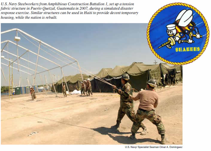
Take one core example: the use of hoop or fabric tension structures. The accompanying photograph shows a type of fabric tension structures, which are in widespread use now in various countries for agriculture, warehousing, military encampments, disaster relief, and many other purposes. These are the successors to the World War II Quonset huts, which were prefabricated structures of corrugated galvanized steel, with a semi-circular cross section.
Similar in appearance, today's hoop or fabric buildings, can be of ultra-lightweight aluminum ribs and thin sheeting; or of ultra-sturdy steel beams, with deep footings and ultra-strong fabric covering.
The structures can be up to 200 feet wide, as long as required, and be trimmed out to meet varying requirements for ventilation, doors, light, etc. The buildings can be fitted inside for barracks-style housing, for dormitory, or for family-unit domiciliaries, to allow high density, but comfort and decency at the same time. There are hundreds of examples of the use of hoop buildings in demanding environments, e.g., an entire hospital complex was built with hoop buildings in Kabul by French military engineers.
In all cases, the materiel is relatively easy to ship, which is a critical factor, given the almost total lack of wood and building materials inside Haiti. Plus, the procurement supply lines stateside, can be a priority for CCC-type programs for U.S. young people to learn skills by working at the building manufacturing plants and input suppliers, and within Haiti, for battalions of young people to help erect the buildings and camps.
The CCC Principle
The same principle of deploying with the CCC brigade approach, applies to building and maintaining all other aspects of Haiti's evacuee camps—water supply, plumbing, and showers; sanitation; power; cooking facilities, medical centers, etc.
In turn, the camp populations include workers of varying ages and skill-potential to deploy as CCC-teams to the differing kinds of national priority nation-building projects. The transportation needs include upgrading hundreds of miles of roads, establishing and expanding airfields, creating warehouse and goods-handling centers, and site-preparation for food processing, and light industry. Port facilities must be upgraded, while, in the meantime, interim docking and loading services can be provided military-style.
An immediate task, is to clear out an estimated 60 million cubic meters of rubble.
 |
Power is a top national priority. Critical to this, is to rehabilitate the Lake Peligre hydropower installation, irrigation systems, and flood management in the Artibonite River basin, and in all other high-hazard flood-prone parts of the country. The second-largest lake in the country, Peligre is a reservoir created by the completion of the Peligre Hydroelectric Dam on the Artibonite River in 1956-57, which is in the Centre Department. The dam is the source of about half of the nation's electricity (the other half comes from oil-fueled plants), but it is in dire need of rehabilitation. Its hydropower potential is currently estimated to be around 173 megawatts. Peligre Lake is about 30% silted up, from sedimentation resulting from deforestation. All this can be reversed.
The U.S. Army Corps of Engineers designed the hydroelectric dam project as part of the program for flood-control and power-provision in the Artibonite River, which in turn was part of the 1930s FDR Artibonite Valley Agricultural Project.
The new FDR-type reconstruction mission will also include bringing Haiti into the nuclear age, with floating nuclear plants (nuplexes) brought to the coast on barges.
Agriculture, Forestry, and Fishing
Haiti's agroclimatic potential is great, because it can grow both tropical and temperate crops and trees. There is good rainfall, and two growing-seasons a year for many crops. In area, Haiti is larger than Jamaica, and about the same size as the state of Maryland. Its miles of coastline make fishing development, including aquaculture, very favorable. Its geomorphological constraints are simply the many slopes—as in Japan, or even Switzerland, and also its vulnerability to hurricanes and earthquakes.
The objective involved is for achieving food self-sufficiency as quickly as possible, and building-up the fertility and plentitude of the land and water resources base of the nation.
The fact that, in recent years, Haiti has sunk to the level of importing 60% of its food overall, and fully 80% of its rice—the nation's staple—is not a reflection of inherent paucity of physical resources of land and water, but the imposed pauperization of the people, and degradation of the resources base, under globalization. With good fertilizer, seeds, timely water applications, and tillage, yields can by raised dramatically for all the crops that can be produced: rice, corn, sorghum, sugar cane, and a wide range of fruits and vegetables (such as mangoes), plus specialties, including coffee, sisal, and aromatic oil plants, etc.
The first of two planting seasons in Haiti is now at hand, which runs March through the beginning of April—which, in the past, accounted for 60% of the annual crop. The second planting season runs from August to the beginning of September. Most of the rural areas of Haiti were not much affected, directly, by the Jan. 12 quake, except for southwestern Haiti, in the range of about 100 km from Port-au-Prince. So the farming mobilization could be underway now.
What is lacking, however, along with the lack of a U.S. commitment to go ahead, are seeds, fertilizer, and tools. The "Agriculture Cluster" of the UN OCHA (Office for the Coordination of Humanitarian Affairs)—82 NGOs and UN agencies led by the Food and Agriculture Organization—in Haiti, reported Feb. 25 having only about 8% of the funds they requested for the season.
A $700 million plan for international donations to rebuild Haiti agriculture was presented Feb. 12 at a Rome meeting of FAO director-general Jacques Diouf and many food policy agencies, and the Haitian Agriculture Minister Joanas Gue. Whatever its merits, or demerits (i.e., premised on world free trade), the funds have not been forthcoming. The plan is going nowhere.
The general parameters of what to pursue, once the Obama Administration obstruction is overcome, are provided by a quick look-back to the crop profile when Haiti was relatively self-sufficient in food, during earlier decades. Back then, of Haiti's total land area of 27,700 sq km (10,714 sq miles), or 2.775 million hectares, about 900,000 ha were considered arable and in crops; another 500,000 in pasture, and barely 70,000 ha were irrigated. All this can be upgraded.
Reforestation can proceed likewise, re-establishing the full range of types, from pines to fruit trees, viable for the right latitudes.
The fisheries potential is likewise significant. Mid-20th-Century coastal surveys showed a wealth of types, such as 270 different fish species in the Gulf of Gonaïves. The conditions for freshwater fish can also be enhanced in rivers and lakes, once water management projects get underway. This is particularly important in terms of animal protein, which the malnourished population urgently requires.
Public Health Mobilization
Mobilizing to provide all aspects of public health—from safe water, sewerage, and nutrition, to disease-vector control, vaccines, and medical care—is an immediate and ongoing priority. As of March 4, the Red Cross/Red Crescent announced that the 100,000th person had been vaccinated in the quake zone, out of a goal of 700,000. The vaccination has five components: against measles, diptheria, pertussis, tetanus, plus the de-worming agent, albendezol, and Vitamin A. Teams are trying to vaccinate 10,000 people a day. But bringing in the personnel to carry this vaccination campaign through faster must be done immediately.
Of special priority, is to launch the most thorough mosquito kill-and-control campaign ever in the island of Hispaniola. The mosquito is the vector for malaria and dengue fever.
The U.S. Centers for Disease Control and Prevention (CDC) said in its March 4 release, "Haiti Pre-Decision Briefs for Public Health Actions," that, "the island of Hispaniola [consisting of Haiti and the Dominican Republic] is the only island in the Caribbean region where malaria has not been eliminated," and that the most prevalent strain—P. falciparum—is "endemic in low-lying areas of Haiti." Falciparum is a killer strain. During the oncoming rainy season, the standing putrid water guarantees more cases, unless acted against.
Even before the earthquake, Haiti had 30,000 confirmed cases of malaria a year, although officials believe that the actual number is closer to 200,000, with a few dozen deaths each year.
Dengue fever is also widely present in Haiti. Under the mosquito-favoring conditions of the rainy season coming on the debris of the earthquake, the CDC said of dengue, "Substantial population susceptibility to infection will exist; ... displaced person camps [in the quake zone] will most likely have unique vector (and dengue virus) population dynamics." This is polite CDC language for "holocaust," but the epidemiological point is clear.
The population must be relocated out of the unlivable conditions in the quake zone. With evacuees safe on high ground, a full-scale national sanitation campaign can be launched, with clean-up, drainage, and DDT, to defeat malaria entirely, and roll back dengue as fast as possible.
FDR and the Army Corps of Engineers
This emergency relocation, and infrastructure plan for Haiti is precisely in the American System tradition of deliberate nation-building. Specifically for Haiti, it is embodied in the 1934 FDR Good Neighbor Policy, during which the U.S. Army Corps was deployed to work on water management improvements in the Artibonite River basin, for what, in 1956, included one of the largest hydroelectric dams in the Americas.
Had this development approach been continued, instead of side-tracked by the post-World War II, anti-FDR shift to globalization and impoverishment, we now would be christening new floating nuclear power plants, for installation in Haiti and other special sites. That will come, if we take the needed rescue measures now called for.
The Army Corps of Engineers has already done the groundwork for evacuating the quake victims and getting to work on the country. In August 1999, the U.S. Army Corps of Engineers District in Mobile, Ala., and the Topographic Engineering Center in Alexandria, Va. released "Water Resources Assessment of Haiti." The hydrologists wrote: "This assessment can aid the host nation by highlighting its critical need areas, which in turn serves to support potential water resources development, preservation, and enhancement funding programs. Highlighted problems are the lack of access to water supply by much of the population, the density of the population and the high mortality rate, the lack of wastewater treatment, the devastating effects of deforestation on the water resources, and the lack of hydrologic data. Watershed management plans should be enacted to control deforestation and to manage water resources...."
In the emergency we face today, those with logistics experience, who know the array of task-requirements, can determine the staffing objectives, to increase the U.S. Army Corps of Engineers ranks from its current size of 34,000—far too small—to double or triple that size, to undertake the infrastructure-building needs in Haiti, and within the United States, too. Retirees and reserves can help fill out the roster.
But the main deployment will come from hundreds of thousands of Haitians, and from the U.S. unemployed young people, who, with leadership and hands-on experience, will learn on the job, and accomplish the mission.
Related pages:
LaRouche Demands Urgent U.S. Action To Prevent Rainy Season Devastation
Lyndon LaRouche January 30, 2010: The End of the Obama Administration