
The World Land-Bridge:
Rediscovering
The Americas
by Dennis Small
September 2014
This article appears in the September 12, 2014 issue of Executive Intelligence Review and is reprinted with permission.
A shorter version of this article will appear in the soon-to-be-published EIR Special Report on the World Land-Bridge.
 |
|
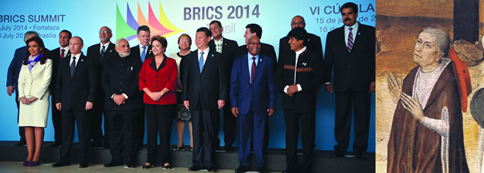
Agencia Brasil/José Cruz
Leaders of the BRICS, joined by South American heads of state, in Fortaleza, Brazil, July 16, 2014. |
Nicholas of Cusa |
September 1—It was the revolutionary 15th-Century philosopher and founder of modern science, Cardinal Nicholas of Cusa, who played an instrumental role in the project that led to the 1492 “discovery of the Americas” by Christopher Columbus. Columbus was working from a map provided by Paolo dal Pozzo Toscanelli, who was closely associated with Cusa. It was also Cusa who famously wrote in his 1450 The Layman: About Mind: “Mind is a living substance. . . . Its function in this body is to give it life and because of this it is called soul. Mind is a substantial form of power.”
If the Americas, like the rest of the world, are to be saved from the economic disintegration and New Dark Age now besetting them, it will have to be on the basis of rediscovering—and rebuilding—the hemisphere, based on applying that “substantial form of power” which Cusa invoked. That process is now underway with the momentous July 15-16, 2014 summits of the BRICS nations and Unasur,1 sparked by Argentina’s courageous fight against the criminal vulture funds.
Under the current trans-Atlantic financial system, as distinct from the process initiated at those summits, the region, especially its youth, has no future, thanks to the British imperial policies of looting imposed by the IMF and Wall Street for decades. Under the old system, these young people face only the deadly choices of unemployment, joining a drug gang, or emigrating in search of mere survival. The potential relative population density (Lyndon LaRouche’s metric of a society’s power to sustain a growing, productive population) has fallen below the actual population levels in most countries today, meaning that they can no longer keep their own populations alive, based on physical-economic activity. The first to pay the price are the youth.
Exemplary is the case of El Salvador in Central America, where over one-third of the population has fled to the United States to try to survive. In neighboring Honduras, official unemployment now stands at 60%, but knowledgeable Honduran sources say the reality is closer to 80%. In Mexico, about 18% of the population has been driven to the United States over two generations by an economy incapable of providing elementary survival. Pope Francis, pointing to the staggering youth unemployment in many countries, including much of Ibero-America and southern Europe, described the situation as “unbearable. . . . We are excluding an entire generation of young people.”
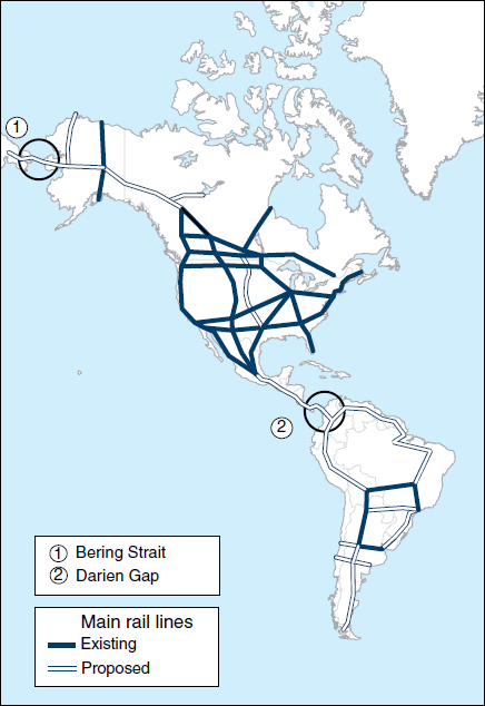
FIGURE 1
The Americas: Priority Routes
 |
The alternative to this destruction? Launch great infrastructure projects as part of the World Land-Bridge. Begin the rebuilding of national economies, and undertake mutual-interest trade. Outlaw slave-labor/free-trade practices. With the millions of productive new jobs so created, the people of the Americas, especially the youth, can look forward to building, not leaving, their homelands.
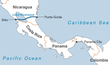
This is the revolutionary transformation that has been unleashed by the BRICS process. Exemplary is one of the projects undertaken in the framework of the BRICS summit: the construction of an inter-oceanic canal through Nicaragua. Not only will this project be a vital component of the World Land-Bridge; it is expected to employ some 50,000 construction workers directly, and once operating, it will generate over 200,000 jobs.
In fact, the entire region of the Americas, from the tip of Alaska in the North, to Tierra del Fuego in the South, presents enormous challenges to biospheric engineering which will require fully activating Cusa’s “substantial form of power” to conquer them. In the far north, there is the plan for a Bering Strait tunnel (Figure 1), probably the single most decisive project for the World Land-Bridge, as it will connect Russia and the United States, and all of Eurasia, to the entirety of the Americas.
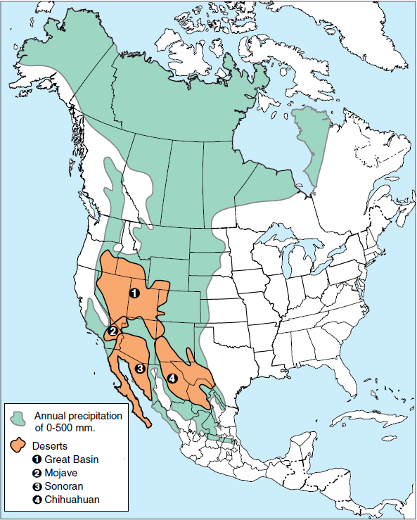
Moving southward, there is the Great American Desert (Figure 2), a swath of arid and semi-arid land which covers a large part of the U.S., Canada, and Mexico, which can only be revived by massive bioengineering, beginning with mastery of the huge flows of water, not on Earth, but in our atmosphere. Then there is the Darien Gap (Figure 1) connecting Central and South America, where there is still no road—let alone a high-speed railroad—which must be built to cut through the jungle and link the Americas together, and provide a continuous rail connection from South America into all of Eurasia.
In South America proper, there is the world’s greatest river, the Amazon, with the enormous Amazon jungle and its untold, untapped resources. And there are the Andes, a mountain range which runs the length of South America just east of its Pacific Coast—a formidable barrier to the necessary construction of a transcontinental railroad across South America. But this project was also undertaken as a tri-national enterprise among Brazil, Peru, and China at the BRICS Summit, a fitting answer to the way one Peruvian described her country: “Peru is God’s challenge to engineers.”
The outlook required is that of the Peruvian patriot Manuel Pardo, who as President (1872-76), in alliance with Abraham Lincoln’s networks in the United States, launched a national railway project which included crossing the Andes. Their enemies sarcastically dubbed it “the train to the Moon.” But Pardo already knew, in 1860, the enormous role to be played by railroads:
“Join the three central lines by means of the fourth, and decide if, in ten years, a revolution will not have occurred in Peru, a revolution at once both physical and moral, because the locomotive—which, like magic, changes the face of the country through which it passes—also civilizes. And that is perhaps its main advantage: Populations are put into contact. It does more than civilize; it educates. All the primary schools of Peru could not teach in a century, what the locomotive could teach them in ten years.”
Rail Links the Americas to the World Land-Bridge
FIGURE 2
The Great American Desert
 |
The size of the landmass of North and South America combined (16,300 mi2, or 42,215 km2) is second only to Asia (17,400 mi2, or 45,065 km2). The economic development potential of the Americas is vast, both in terms of the given natural resource base, and manmade “natural” resources—created through infrastructure projects. The maps shown here represent only a brief survey of selected key projects that EIR has promoted for decades, many of which have been on the drawing boards of various governments and international agencies also for decades—and even centuries!—awaiting only the policy go-ahead.
The priority high-speed (and preferably maglev) rail routes shown in Figure 1 are not simply proposed speedy travel routes from point to point, with connections to Eurasia/Africa. Rather, these routes indicate corridors of development, whose patterns arise from topography, mineral and other physical resources, and historical settlement patterns (where populations are already concentrated, and where proposed new development zones should be). The rail route/corridors indicate intended locations of new concentrations of energy, water, agricultural and industrial activity, and also, centers for health care, and cultural and educational activity.
In North America, the plan is simple. First, build the intercontinental lines planned for decades: the United States/Canada/Alaska line—already mapped out by the Army Corps of Engineers in the 1940s. Second, build the Pan-American rail connection southward, linking Central and South America with the North, likewise planned for decades—in fact, over a century. Third, upgrade the existing rail grid in Mexico, the United States, and Canada, which had been developed as of the mid-20th Century, but was largely taken down during the last 40 “post-industrial” years. The priority routes for high-speed are shown. Note, in particular, how Mexico City in central Mexico is interlinked with the entire northward grid, and to the south.
FIGURE 3
South America: Transcontinental Railroad
EIRNS |
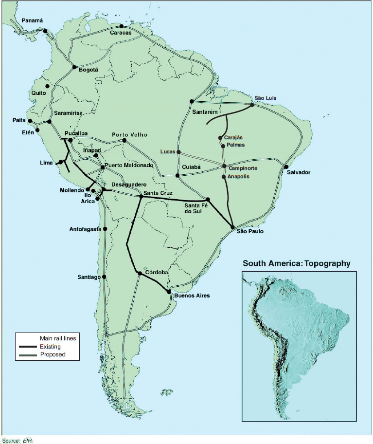
In South America, (Figure 3) shows priority rail routes to be built, both to ring the continent, proceeding along the Andean spine in the West, as well as across the mountains, connecting the Atlantic and Pacific coasts. This kind of network will integrate growing economic activity. As of the mid-20th Century, parts of Argentina and Brazil had relatively dense regional rail networks, which were undermined over the last 40 years. A continental grid was never built at all. The little that currently exists is indicated on the map, often reflecting the classic colonial policy of building a railroad leading only from a mine to the port, so that raw materials could be exported for foreign exchange, which was then used to pay the ever-growing foreign debt.
This overall rail project took a significant step forward at the July BRICS Summit, where the idea of fulfilling the centuries-old dream of building a transcontinental railroad connecting the Atlantic and Pacific coasts of South America was taken up among Brazil, Peru, and China, in discussions between Chinese President Xi Jinping and Peruvian President Ollanta Humala, and then with Brazil’s President Dilma Rousseff. An agreement was reached to open bidding for foreign, including Chinese, companies, to participate in the construction of one critical segment of that project: the “T”-shaped Palmas-Campinorte-Anapolis/Campinorte-Lucas route in central Brazil.
FIGURE 4
Intercontinental Railway Commission
A small section of the 1898 survey map for the Intercontinental Railway. After President McKinley was murdered, no raliway or road was ever built connecting North and South America. |
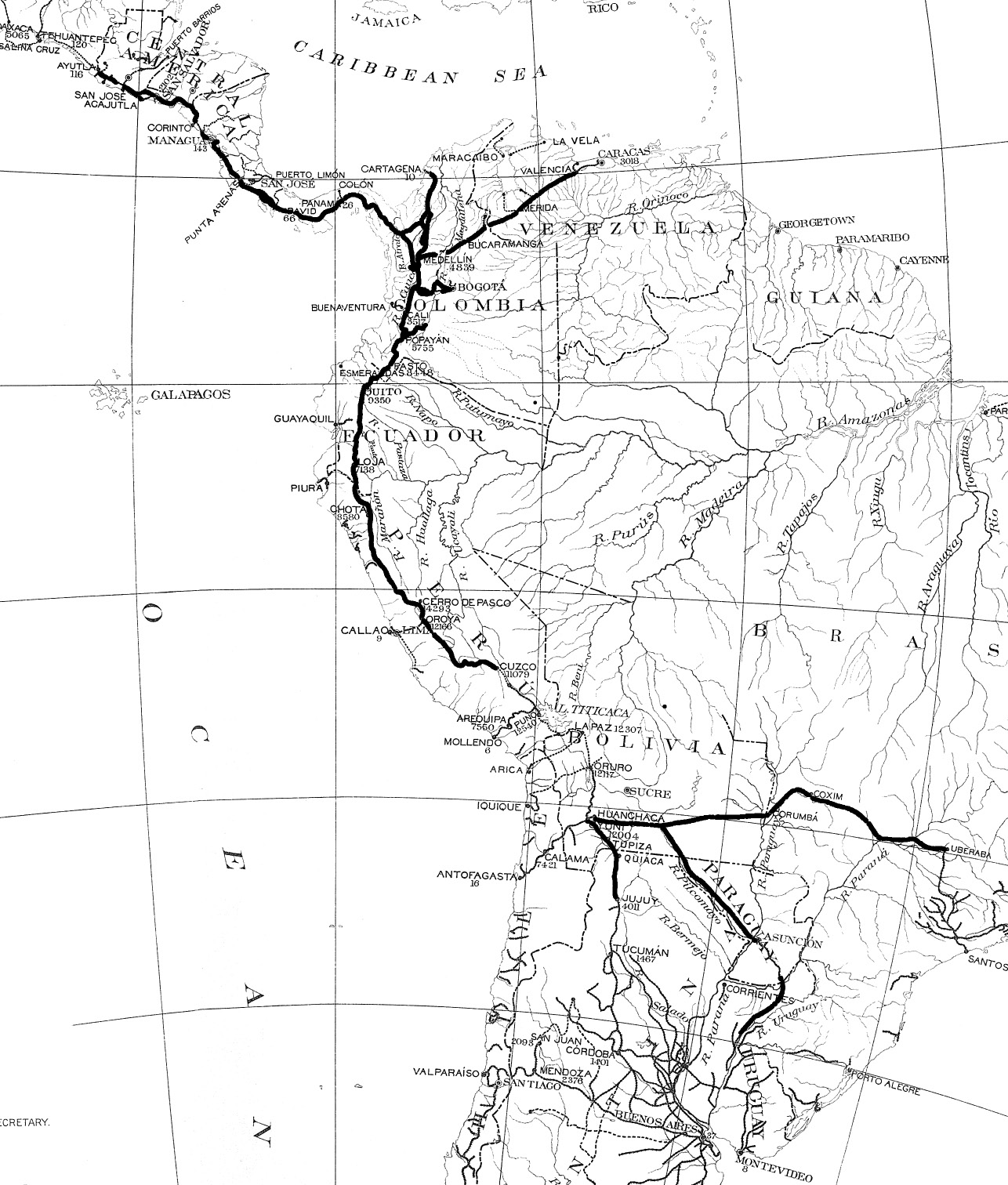
The importance of that segment within the overall project presented by EIR is clear from Figure 3, a schematic map, first published by EIR in 1988. The northern terminus of Palmas is a stone’s throw from the famous Carajás project in the middle of the Amazon jungle, the world’s largest (and purest) iron ore deposit, which is now connected by rail only to the Atlantic port of São Luis. Once built, the western rail terminus of Lucas would then be halfway to the Brazil-Peru border, where the projected rail line would link up, in one option presented by EIR, with a Peruvian branch that would cross the Andes at Saramirisa—the lowest pass in that giant mountain range—and from there, to one or more Peruvian ports for shipment across the Pacific Ocean. This would drastically cut shipping time and costs from Brazil (and other Southern Cone countries such as Argentina) to Eurasian powerhouses like China, India, and Russia.
Even greater efficiencies, growth, and productivity can be achieved as this South American Transcontinental Railroad is able to connect directly by rail with Asia, as super-high-speed maglev rail lines are constructed through the Darien Gap and the Bering Strait.
There are various possible routes for a South American Transcontinental Railroad. (The one under discussion among China, Brazil, and Peru centers on São Paulo-Santa Fé do Sul-Cuiabá-Porto Velho-Pucallpa-Saramirisa-Bogotá-Panamá, with Andean crossings at either Pucallpa or Saramirisa.) Another viable option, which has long been studied, is São Paulo-Santa Fé do Sul-Santa Cruz-Desaguadero-Saramirisa-Bogotá-Panamá, with Andean crossings at Desaguadero, Pucallpa or Saramirisa. In fact, earlier versions of precisely this project were drawn up by the Intercontinental Railway Commission, started by U.S. Secretary of State James Blaine, which employed U.S. Army engineers to survey and project lines tying the United States through to Argentina and Brazil, presenting a completed map of the intended route project to President William McKinley in 1898 (Figure 4). The strongly pro-American System McKinley commemorated Blaine’s plans as the future of humanity, speaking in 1901 at the Pan-American Exposition in Buffalo—where McKinley was shot dead in a British-run operation.
Three Centuries of Great Water Projects
Figure 5 shows South America’s priority water-improvement projects for intra-continental navigation, as well as flood control, power, irrigation, and other uses. The continent is well-endowed with navigable rivers (solid lines). The proposed canals (dotted lines) form key link-ups for a continuous inland water route. The idea dates back at least to Alexander von Humboldt in the 19th Century, who conceived of linking South America’s three major river systems—the Orinoco, the Amazon, and the Rio de la Plata—with North America as well. He visualized the route going from the mouth of the Orinoco north through the Caribbean Sea, and into North America via the Mississippi and Tombigbee Basin, or via the East Coast—thus, an intercontinental “Great Waterway of the Americas.”
FIGURE 5
South America: Great Water Projects
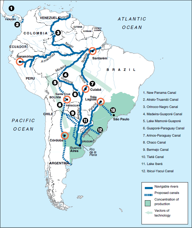 |
More recently, in the late 20th Century, “The Great Waterway” was the name given by Brazilian expert Vasco Azevedo Neto, for the north-south link-up of the Orinoco to the Amazon system (No. 3 on the map), and the Amazon to the Rio de La Plata (No. 7). This inland waterway would also link up inter-modally with the railroad project described above. For example, the Amazon can be made navigable as far west as Saramirisa in Peru, where one of the possible transcontinental rail routes would cross the Andes to the Pacific Coast.
The shaded “Production Concentration” area, spanning parts of Brazil, Uruguay, and Argentina, refers to the concentration here of population, industry—in particular machine-tool capacity—science, and R&D, and output potential of all kinds (aviation, steel, automobile, nuclear power, high-tech farming), which can provide needed technology-transfer inland, throughout the continent—indicated by the shaded arrow-vectors.
FIGURE 6
Nicaragua Interoceanic Canal
EIRNS |
Another great water project, the construction of an Inter-Oceanic Canal through Nicaragua (Figure 6), was announced on July 9, by Nicaraguan President Daniel Ortega, in the lead-up to the BRICS Summit. The massive project will be carried out by the Chinese company HKND, but Russian President Vladimir Putin also made an unannounced stopover in Nicaragua on July 12, on his way to the Summit, to offer Russia’s support as well. The canal will run 173 miles from the mouth of the Brito River on the Pacific Coast in southwestern Nicaragua, to the mouth of the Punta Gorda River on the Caribbean side. It will include two locks, and 65 miles of it will pass through Lake Nicaragua, and have a projected passage time of 30 hours, coast to coast, for the 5,100 of the largest ships in the world that will be able to use this canal.
Project engineers report that over 50,000 construction workers will be required, and that, once in operation, it will generate 200,000 jobs, including its sub-projects (an airport, two ports, a tourist center, etc.).
President Ortega, in announcing the selected route, stated that the country’s educational system was being revamped to produce the engineers and skilled workers that the project will require. He also held up a book containing the feasibility studies for constructing such a canal that had been produced by the U.S. government, and adopted by the U.S. Congress, in 1896, detailing the benefits that such a canal would bring.
The irony was lost on no one. China is actively involved in massive job-creating economic projects in Central America—the United States’ proverbial “back yard”—while the U.S. under Obama has helped destroy that area with his policy of drug legalization, on top of decades of the British Empire’s free-trade economic devastation.
Tripling Ibero-American Food Production
With adequate infrastructure, especially rail and water projects, Ibero-America is capable of nearly tripling its current levels of food production in a decade. Figure 7 focuses on two areas with vast agricultural potential: the Colombian-Venezuelan Plains, and Brazil’s Cerrado. The Amazon jungle lies between them.
FIGURE 7
South America: Great Rail and Agricultural Projects
 |
The Colombian-Venezuelan Plains are a continuous stretch of some 50 million hectares (212,000 mi2) in the Orinoco River basin. There is significant annual rainfall—in fact, too much in certain seasons—and there are major rivers which cross the region, including the Meta and the Guaviare. The land, once it has been treated with lime (3-5 tons per hectare) to address the problem of acidity, is well-suited for agriculture. Today, it is vastly underpopulated, underdeveloped, and largely controlled by London-promoted drug-trafficking armies. For example, the Colombian portion of the region (about 60% of the total for the two countries), constitutes 27% of Colombia’s national territory, but has only 3% of its population—some 1.5 million inhabitants. There are few roads in the region, and no railroads.
In size, the Colombian-Venezuelan Plains are equivalent to the combined area of the U.S. Great Plains states of Nebraska, Kansas, and Iowa.
Next, turn to the huge Cerrado region of Brazil, which is nearly four times larger than the Colombian portion. Its 205 million hectares (792,000 mi2) are equivalent to the three mentioned U.S. states, plus North Dakota, South Dakota, Missouri, Oklahoma, and Texas. Parts of the Cerrado are a bit more developed than the Colombian-Venezuelan Plains, largely by the international grain cartels, which exploit huge tracts of soybeans, and process them almost entirely for export.
The Cerrado is a vast tropical savannah, a well-watered grassland, which constitutes 24% of Brazil’s total land area of 846 million hectares—which, in turn, is 9% larger than the continental United States. Three main river systems drain the region: the Araguaia-Tocantins (into the Amazon Basin); the Paraná (southward to the Río de la Plata Basin); and the San Francisco (to the Atlantic Ocean). Like the Colombia-Venezuela Plains, with the right fertilizer and lime applications to the soils, the region’s agro-climatic potential is vast. The temperature regime for much of the Cerrado will permit two, and sometimes three crops a year.
As we indicate in Table 1, some 50 million hectares out of the Cerrado’s total of 205 million can be put under crop cultivation. This will produce about 210 million tons of grain per year. Similarly, in the Colombian-Venezuelan Plains, grain can be grown on some 15 million of its 50 million hectares, producing about 60 million tons.
| TABLE 1 Ibero-America’s Great Agricultural Projects: Grain Production |
|||
| Total Land Area (Million Hectares) |
Area Cultivated (Million Hectares) |
Production (Million Tons) |
|
| Ibero-America today | 2,058 | 51 | |
| —Production | 160 | ||
| —Imports | 40 | ||
| —Consumption | 200 | ||
| —Consumption, no hunger | 260 | ||
| —Consumption, 2018 | 350 | ||
| Colombia-Venezuela Plains | 50 | 15 | 60 |
| Cerrado | 205 | 50 | 210 |
| Mexico, NAWAPA-Plus | 196 | 5 | 20 |
| Sub-Total, 3 Projects | 70 | 290 | |
| Total, Today + 3 Projects | 450 | ||
| —New Total as % of Today | 281% | ||
Source: FAO, EIR. |
|||
If we add in the significant increase of irrigated land—and thereby food output—that can be achieved in Mexico with the implementation of the combined NAWAPA, PLHINO, and PLHIGON water projects, a total of 290 million tons of additional grain can be produced in Ibero-America. This will make for a near tripling of the current, inadequate output of 160 million tons of grain per year. Even if we factor in: a) replacing current imports (40 million tons) with regional production; b) bringing food consumption levels up to the point where hunger is eliminated for the 40-50% of the population today suffering from it (another 60 million tons); and c) providing for a 3% yearly population growth over the decade that it will take to bring these projects on line (90 million additional tons); the total required grain production of 350 million tons by 2018 will be more than matched by the 450 million tons that will be produced. Regional food self-sufficiency is unquestionably an achievable goal.
Energy for Economic Development
Critical to “rediscovering” the Americas is the provision of plentiful, cheap energy, with a technological platform characterized by high and rising energy-flux density. This means the appropriate combination of high-tech use of fossil fuel deposits, hydro-power potential where available, and most importantly, everywhere, the resumption of nuclear power development, leading directly into planet-wide cooperation on building a fusion-based world economy.
Soon after the 1953 announcement by President Eisenhower of the “Atoms for Peace” program, Argentina became the first nation to sign an agreement for cooperation on the peaceful uses of nuclear power. Its first reactor came online in 1974, the Atucha I; and its second, the Embalse, in 1983. As of 1979, four new plants were planned to go operational between 1987 and 1997, but the British Empire’s “green” policy and IMF austerity dictates stopped all such programs—until recently. Atucha II finally came online in 2014.
In Brazil, the same British anti-nuclear policy was imposed, even though scientists were conducting experiments in nuclear fission there in the 1930s. Today, only two Brazilian plants are operational, Angra I (1982) and Angra II (2000).
In Mexico, President José López Portillo (in office 1976-82) had plans for 20 nuclear plants. Today, there are two, both at Laguna Verde.
In all of the Americas, there were 126 nuclear generating plants operational in 2014: United States, 100; Canada, 19; Argentina, 3; and Brazil and Mexico with 2 each. Engineers had said 50 years ago, “2,000 by 2000!”—the world needs 2,000 nuclear plants by Y2000. But as of 2014, there were only 437, with a mere 70 more under construction.
But a renewed drive for nuclear energy has emerged from the BRICS Summit. Argentina is moving forward rapidly to build additional plants, as is Brazil, with Russian and Chinese collaboration.
But perhaps most moving—and indicative of the paradigm shift that is now underway—is the vigor with which Bolivia has opted to go nuclear. As Vice President Álvaro García Linera put it so eloquently at a late August energy conference in Santa Cruz:
“The use of and training in atomic energy is one of our obligations as a society and as a State. We have made that decision, and we are going to guide ourselves based on that decision. In the coming years, we will implement a program of nuclear energy for peaceful purposes, with medical and agricultural goals, as the case may be, but we will have an elite, a core of brains, integrated with the world, to networks who work in the atomic field, which will allow Bolivia to learn about and use this fire of the 21st century: atomic energy.
 |
“Nuclear energy is the fire of the 20th and 21st centuries. It is the fire which our ancestors had 20,000 years ago, which allowed them to make philosophy, technical science, culture, agriculture. Knowledge of the atom, its regularities, its use, its functioning, is the touchstone of the 20th and 21st centuries, the fundamental core of new knowledge and new technologies, new theories and new means of production. . . .
“Bolivia cannot remain on the periphery, if this is the case, if knowledge of the atom . . . is the sacred fire of the 20th and 21st centuries, as fire was for the pre-agricultural civilizations of 20,000 years ago. Today a society which is respected—and we respect ourselves—cannot remain on the periphery, and we are not going to remain on the periphery. . . .”
“Fire in itself is not the destroyer,” he said, and nuclear energy is not the destroyer. It can be “a creative productive force of life or a destructive force.”
“Nuclear energy exists independently of us. It functions in nature, in the human body, in physical and chemical processes. The question is, if we have the ability as society, to learn about it, to know it, to respect its force and to know how to use it collectively and humanly for beneficial purposes. . . .
“Let us break the mental and colonial chains; break them! Let us dare to leave the cave, as our ancestors did 20,000 years ago. Let us dare to assume our responsibility before the world, before our history and our society. Knowledge of nuclear energy is knowledge of the ABC’s of nature. . . .
“[Bolivia has] the technical, scientific, and moral obligation to take responsibility for the knowledge, use, understanding, and beneficial development of this fundamental force of nature. It doesn’t matter how long it takes us. We are going to do it, because we are convinced that that is how we cement the conditions for the technological development of Bolivians for the next 400 to 500 years.”
1. The BRICS nations are Brazil, Russia, India, China, and South Africa; Unasur is the Union of South American Nations.