III. The BRICS—
The Next Stage of Mankind
Create Water Resources—China, the World Model
by Marcia Merry Baker
April 13—China is the world model for commitment to providing and utilizing an increasing water supply, based on the principle that “natural” resources are man-made. China is the leader in both geo-economic projects to make available more water from existing resource patterns on Earth, and in pursuing advancement in space research, to gain the knowledge and means to intervene in planetary moisture cycles, to improve the resources of the Earth. The measure? Progress of mankind.
China completed the Three Gorges Dam, the world’s largest, in 2008. China has completed, as of 2014, the first two of three water conveyance channels, for the South-North Water Diversion Project, the world’s largest. The nation is proceeding on nuclear power, with 28 reactor stations under construction, and a goal of tripling its nuclear capacity by 2020. There are key initiatives for nuclear-powered seawater desalination. In 2013, China landed its rover, Yutu, on the Moon—signifying its general drive for space research, essential to the future of life on Earth.
These actions by China are critical for the United States, which, across the Pacific, is facing doom for refusal to take necessary measures to create more water. The United States urgently needs to collaborate with China on all aspects of water policy, from space science to infrastructure engineering.
China’s emblematic, outstanding water infrastructure project—the Three Gorges Dam—is not only an instructive, “Extreme Engineering” success, but it is an inspiration for all humanity. It shows the mind-of-man at work.
South-to-North Water Diversion
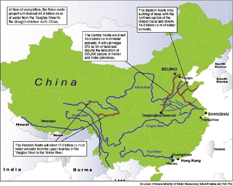
In December 2014, the first “new water” began arriving in water-short Beijing from the Central Route of the grand South-North Water Diversion Project (SNWD), a three-route scheme for diverting flow northward to the water-deficient North China Plain, from the various parts of the water-plentiful Yangtse River Basin. This Central Route system takes water north through some 1,200 km of channels and pipes, from its southerly origin in the middle reaches of the Yangtze River Basin. In December 2013, the Eastern Route of the SNWD was opened, and is now taking water from the lower basin of the Yangtze, northward to the lower reaches of the Yellow River. This Eastern Route follows China’s ancient Grand Canal. The Western Route is still in the planning stages.
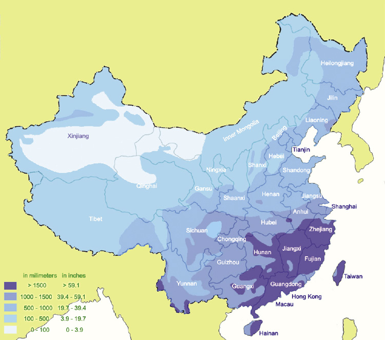
Figures 1 and 2 show national maps of the situation: the highly uneven rainfall pattern; and the schematic picture of how the SNWD routes are designed to move water from the regions of water abundance northward, to regions of scarcity.
The far northwest of China is a continuation of the desert drylands from north Africa, across Arabia, thence spanning Southwest and Central Asia. This aridity pattern decreases eastward, as the monsoonal effect comes into play, to the point of very high rainfall in Southeast China. The great Yellow River (Huanghe) in Northern China, courses through drylands and loess formations, and in several places, its river bed is higher than the surrounding plains! The long Yangtze River, rising in the highlands of the Tibetan Plateau, has a large catchment area, with a sizable flow, emptying at Shanghai, into the sea.
Diverting plentiful water northward has long been discussed, most seriously after the 1949 Revolution. Then, in 1958, the Yellow River and Yangtze River Commissions began to study seriously the possibility of sending water north, and investigations were continued for over 40 years.
In 2002, the China Water Resources Ministry announced that construction would commence. Zhang Jiyao, Vice Minister of Water Resources, said at a November press conference that year, that the new project would create three new man-made “rivers.” He said it would be carried out as a “mega-project that is strategically aimed at realizing the optimal allocation of water resources” in China.
With the future completion of the western diversion route, the total SNWD system, when complete, will be transferring 44.8 billion cubic meters of freshwater to the parched north. (Compare this with the total annual flow of the Yangtze, which is 600-950 bcm). This is vital for Northern China, where amost 60% of China’s farmland is located, and 45% of its population lives. However, it was known from the start, that it would not be enough.
What characterizes the SNWD, the Three Gorges Dam, and other big projects in China, is the commitment to seeing them through as a continuing process. In September 2014, when the sluice gates on the Central Route system were ceremonially opened for the first time, a national water spokesman stressed to CCTV, “We know this won’t solve everything. We will still need more water. But we will solve that in the future.”
That makes the many “firsts” and “records” set in the course of constructing the SNWD, all the more delightful. In Beijing itself, which is receiving two-thirds of the Central Route water, extensive underground storage and transmission facilities were built, sometimes at a depth of 15 stories.
The world’s largest aqueduct is on the new Central Route. It carries Central water overtop the Tuanhe River, at a flow of 420 cubic meters per second. The structure is “built to last a century,” the senior engineer Yu Pengtao told CCTV last Fall. “This aqueduct is no doubt the number one such structure in the world, in regards to water capacity, scale and weight. The design requires high precision and a scientific approach.”
The Central Route flow has to cross some 170 rivers, in the watersheds of the Yangtze, Huaihe, Haihe, and the Yellow rivers. Engineers designed aqueducts, canals, and tunnels to deal with this, their plans driven not simply by hydraulics, but to minimize intermingling of freshwater with polluted water. Reduction of pollution of water, land, and air is a major goal and necessity in China today.
At the same time that progress on the SNWD proceeds, other water infrastructure projects are underway. In June 2014, the third-largest dam in the world was opened, the Xiluodo Dam on the upper stretch of the Yangtze River. In July 2014, the world’s sixth-largest dam, the Xiangjiaba, opened, also on the upper Yangtze. China alone now has more large dams than the rest of the world combined.
‘Desalination Cities’—Nuclear Power
China is moving staunchly on seawater desalination, with important initiatives for nuclear-powered desalination, toward a future massive scale. In February 2012, China’s State Council set a desalinated water target for the 12th Five-Year Plan (2011-15), including a program to build a chain of desalination facilities along the dry northeastern coast. This involves sites from Shandong to Liaoning. The list was expanded in 2013, when the National Development and Reform Commission announced the addition of new coastal cities.
Currently, the overall target set by the central government’s Special Plan for Seawater Utilization calls for a fourfold increase—up to 3 billion liters—by 2020, in the country’s current capacity. Work is underway on both non-nuclear and nuclear desalination.
On the shore of Bohai Bay, for example, construction has started on a thermal desalination plant near Tangshan, part of whose output—planned to begin in 2019—will then be piped 270 km to Beijing. Work on this new water pipeline has begun. The project is being done jointly by the Norwegian firm Aqualyng, and the Hong Kong-based Beijing Enterprises Water Group.
There are projects at other points along the chain of “desalination cities,” at various stages of progress. These include Dalian, Qingdao, Shenzhen, Shoushan, Luxixiang Island in Zhejiang Province, Binhai New Area in Tianjin, Bohai New Area in Hebei, and a number of industrial parks.
The chain of “desalination cities” also includes pre-existing de-salting operations, for example, at the port city of Tianjin, where the Dagang coal-powered plant has been producing 3,000 cubic meters a day for 15 years for cooling, with a U.S.-designed multi-flash (MSF) unit. The Tianjin Beijing Power and Desalination Plant, specially designed and built by Israel’s IDE Technologies, is one of the world’s largest thermal plants using multi-effect distillation (MED), and the largest desalination plant in China. It began operating in 2010, and produces 200,000 cubic meters a day, about one-third of China’s current desalinated water output.
Nuclear power is the precondition for mass-scale desalination of seawater and inland brackish water, which is needed at many locations across Eurasia. At present, China has 21 nuclear power stations (the first went on line in December 1991), with 28 more under construction. Although by percentage of type of power generation, nuclear will still be under 10% of China’s power base when the project is completed (contrasted to the U.S. at 20%, or France at 50%), the commitment to a nuclear future is clear.
There are some nuclear desalination initiatives. The new Hogyanhe nuclear power project in the northest, at Dalian in Liaoning Province, undertaken by CGN (China General Nuclear Power), will use waste heat to desalinate 10,080 cubic meters of seawater per day, to provide its cooling heat. Chinese authorities are looking at a seawater desalination facility on the Shandong Peninsula, in the Yantai area, to produce up to 160,000 cubic meters a day by MED, using a MWt (thermal megawatt) NHR-200 reactor.
Water from Heaven
China’s leading role for advances on Earth is exemplified by the December 2013 landing on the Moon, by its rover, the Yutu (Jade Rabbit), after an almost 40-year pause in mankind’s activity on the Moon. This successful project reflects China’s commitment to seek maximum knowledge of, and dominion over, the processes of our universe. China has put forward its next immediate steps in a 2014 statement, “Lunar Exploration Program.” There is work underway for a lunar base of operations, with a focus on new energy development, and circumstances for living, as a base for further space probes.
China’s initiative and effort constitute the means—through new instrumental readings, new insight and thought—to reach to a higher understanding, in particular, of the dynamics of Earth’s water cycles. This can be the basis for modifying what have seemed to be intractable climatic patterns, to the lasting benefit of all.
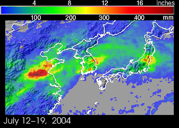
China itself is hostage to a fierce pattern of dryness in the west and north, while being pelted in the southeast by the Summer monsoons. The NASA image shown here (Figure 3) is a satellite view of a monsoon centered on eastern China. It captures a rare instance (July 2004) in which a big monsoon went even farther north from its typical range—still not as far as Beijing—-and dumped more than 16 inches of rain (red) in just a week.
Across the Pacific Rim, the United States West is also drying out, a hostage to the phenomenon of the Pacific atmospheric river (the “Hawaiin Express”) flowing in from the ocean, but not regularly dropping its rainfall potential on land.
Hoping for a monsoon, or praying for rain, isn’t a viable policy. Being able to direct or influence these large water dynamics is the future. The China space policy is the commitment to progress that can ultimately bring rain from Heaven.
marciabaker@larouchepub.com
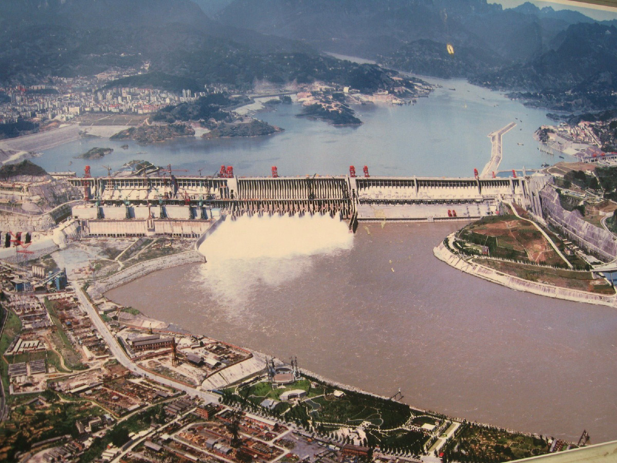
CC/Pedro Vásquez Colmenares
The Three Gorges Dam, largest in the world, opened in 2008; it generates 22,500 MW, and provides flood control.
FIGURE 1
South-North Water Diversion Project
Source: Chinese Ministry of Water Resources, futuretimeline.net; Will Fox
India Must Use Science, Technology, Infrastructure To Give Water to Millions
by Ramtanu Maitra
April 10—India is not a water-short nation. Monsoon rains and ice-melt of the Himalayan glaciers during Summer provide its rivers with more than adequate water; and yet, millions of Indians, mostly women, spend the greater part of their daily lives procuring water manually from a distance, to enable their families to survive. This condition is intolerable, and particularly so, since India possesses the scientific and technological capabilities to generate freshwater, as well as the expertise to develop the infrastructure to transfer water from a surplus river basin to water-starved areas. All it needs is focused efforts to prioritize this vital infrastructure, which would provide an essential ingredient to turn India into a hub of manufacturing and agriculture, and pave the way for a healthy and productive future.
India’s present-day strength in resolving the uneven distribution of its annual water supply across the country, is evident in its proven excellence in its mastery of space and nuclear technology. Both these sources of knowledge and acquired capabilities need to be exercised to deal with its present and future water requirements. India has developed cadres of scientists and experts in these two areas, who should be channeled now to tackle the water problem.
Topology and Types of Rivers
India receives an average of about 4,000 billion cubic meters of rainfall annually, and India’s landmass is close to 3,600 billion square meters. If this water were distributed evenly throughout the country, the landmass would have annually 1 meter’s height of water. However, the rainfall distribution is highly uneven. About 30% of India’s landmass receives an annual rainfall of no more than 750 mm, while 70% receives less than 1,150 mm. In most parts of the country, the monsoon rainfall, which provides the bulk of water, lasts for 3-4 months, but 75% of that rainwater, after flooding large areas, flows into the sea because of lack of water storage and adequate means for transfer of water.
In addition to the uneven distribution and the brief period of rainfall, India’s topology does not allow water from the water-surplus areas to flow into water-short regions.
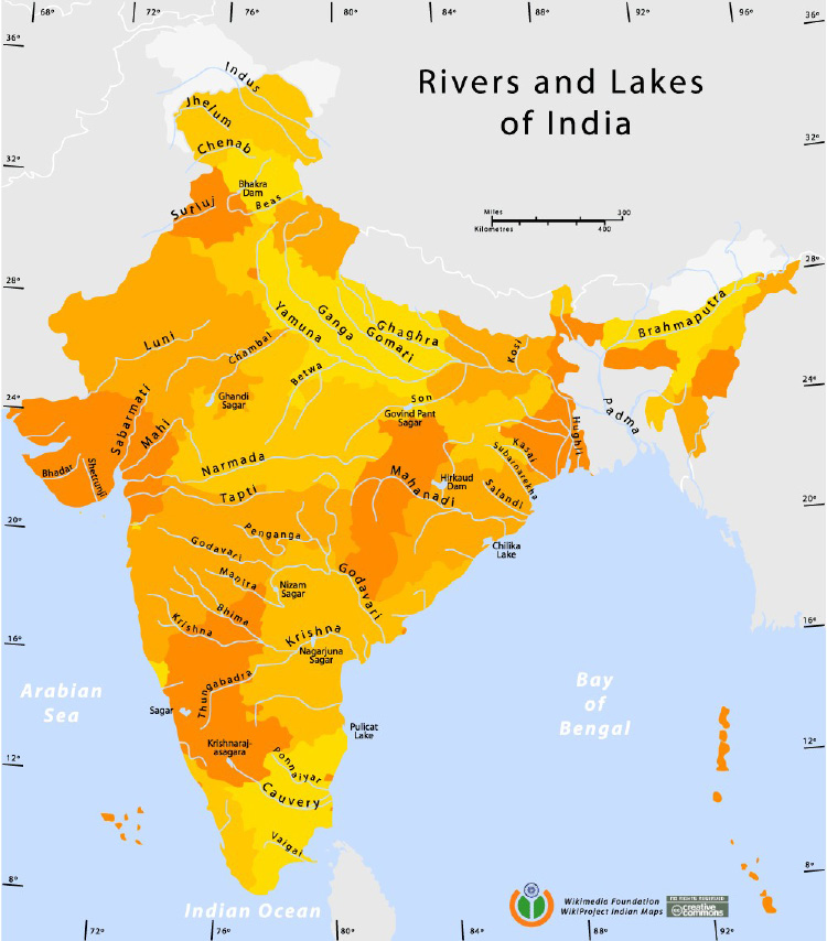
India’s rivers are classified into two categories: Himalayan and Peninsular (Figure 1). The Himalayan rivers are in the north. The main rivers are the Indus, Ganga (Ganges), Yamuna, Brahmaputra, and Spiti, in addition to the five rivers of Punjab—Jhelum, Sutlej, Beas, Ravi, and Chenab. The Jhelum, Sutlej, and Indus rivers flow westward into Pakistan.
The Peninsular rivers in the southern peninsula of India are the Godavari, Mahanadi, Penner, Krishna, and Cauvery.
These two categories of rivers are completely different from each other. The Himalayan rivers rise in high mountains with their sources in glaciers. The ice melt gives them their perennial nature. These rivers flow down from the high Himalayas, a young mountain range, carrying water at a high velocity along with debris from the young mountain, and cutting deep gorges. These rivers have long courses flowing down the mountains, then through level plains and marshy deltaic tracts in the east.
On the other hand, the Peninsular rivers lie in plateaus and low hills that are free from snow. They exhibit a gradual profile, gently flowing through the plateau and narrow coastal plains, depending entirely on seasonal rainfall. As a result, most of these rivers disappear during dry season. Other differences are that the Himalayan rivers are utilized for power generation in hilly areas, and for irrigation, drinking water, and inland navigation in the plains. Their long journey through alluvial plains allows them to build up huge reservoirs of water underground. By contrast, the Peninsular rivers, although suitable for some power generation in their upper reaches, have limited use in irrigation and navigation, confined to the deltaic plains. In addition, the topology of the peninsular region is hard and impermeable, preventing buildup of large underground storage.
India has a long coastline of 7,500-plus km, extending southward from the state of Gujarat in the northwest, to the state of West Bengal in the northeast. Much of the coastline belongs to peninsular India. Coastal areas such as the states of Tamil Nadu, Gujarat, and Andhra Pradesh have a huge problem of water scarcity, due to poor river water availability, low groundwater levels, and high demand. All three states have strong industrial bases and contribute in a large way to the country’s economy. Tamil Nadu and Andhra Pradesh have extensive agricultural lands.
Applying Science and Technology
The key to resolving India’s uneven water distribution, which has caused hundreds of millions to live in perpetual water shortage over decades, lies in using the science and technologies that India has mastered. Back in the 1950s, under the leadership of the late Dr. Homi Bhabha and with adequate support from many accomplished scientists, India started its nuclear power generation program with an eye to resolving the country’s future agro-industrial power requirements. Their competent work, undermined for decades by the Western nations for geopolitical reasons, long ago reached the point that it can also resolve peninsular India’s water shortages.
In addition to mastering the complete nuclear fuel cycle, India produces its own pressurized heavy water reactors (PHWRs). It has installed 16 such indigenous reactors, and many more are in the process of being set up. Most of India’s PHWRs are of a relatively small capacity of 200 megawatts (MW). India is in a perfect situation to utilize small PHWRs and their waste heat, to desalinate water all along the vast coastline, providing domestic, commercial, and industrial water to the water-starved citizens. Hundreds of those nuclear desalination plants, providing at least 300-400 million liters per day (MLD), can be set up all along the coastline resembling a necklace, using the waste heat of indigenous PHWRs for desalination, and the power generated by these nuclear power plants to provide power to the community.
However, India grossly lags in developing this essential infrastructural ingredient using its indigenous technology. Although it has dozens of small desalination plants, in the state of Tamil Nadu only two 100 MLD plants have been set up, and another 150 MLD plant has received clearance. All three plants use or will use reverse osmosis (RO) as the process to desalinate. A 1.8 MLD capacity desalination plant using the RO process has been set up as part of Nuclear Desalination Demonstration Project (NDDP) at Kalpakkam, Tamil Nadu. Another plant, a Multi-Stage Flash (MSF) desalination plant, with a capacity of 4.5 MLD, has also been set up at Kalpakkam, to use the steam from the RO plant as its energy input. The hybrid MSF-RO plant produces distilled water for high-end industrial applications, and potable water for drinking and other applications.
One major problem of the RO, or the seawater reverse osmosis (SWRO) process, is that it does not produce power, but consumes it, whereas in a nuclear desalination project, desalination takes place utilizing the waste heat, while the nuclear power plant generates power for all human uses. Moreover, reverse osmosis membranes are subject to fouling or plugging on the membrane surface. This can decrease the permeate production capacity of the membrane or require an increase in operating pressure (and therefore energy) to overcome the fouling effect. As a result, virtually every membrane desalination facility in the world (including SWRO) requires properly pre-treated seawater. This involves flocculation/sedimentation to remove suspended material; dissolved air flotation (DAF) to remove potential algal biomass or potential hydrocarbons; granular media filtration (GMF); and/or low-pressure ultrafiltration (UF) or microfiltration (MF) to remove suspended particulate matter. The pre-treatment also consumes energy to be supplied from an external source.
Utilizing Space Research
Success in space technology has provided India an opportunity to utilize this hard-earned knowledge to conquer the next frontier, which would provide every Indian with adequate water in the future. Following the successful launching of the Mangalyaan Mars orbital mission (2013) in India’s maiden attempt to put a spacecraft in Mars orbit, Prime Minister Narendra Modi described it as an “historic and spectacular” success. He said he was proud that the country dared to reach out into the unknown and achieve the near impossible.
It is now time to use the accumulated knowledge of India’s space science research. Scientists have worked for years to identify galactic cosmic rays’ positive role in the Earth’s low cloud cover. In 1997, Henrik Svensmark and Eigil Friis-Christensen reported a correlation between cosmic rays and cloud cover. They found that the observed variation of 3-4% of the global cloud cover during the recent solar cycle, is strongly correlated with cosmic ray flux. This was hailed by some as the key to the mystery of how the Sun affects climate and produced climatic changes. It was also a confirmation of the longstanding suspicion that cosmic rays were linked to global cloudiness.
Of particular interest is the observation from recent satellite data, that the cosmic ray-cloud correlation is much more intense in low-level clouds than in high-level ones. On the other hand, utilizing human-generated, negatively charged ions to attach to the condensation nuclei in clouds, would enable the water drops to grow and turn into rain.
Physical Infrastructure
One other essential requirement for India is to augment water-short areas of the Peninsular rivers, by transferring surplus water from the Himalayan rivers. It was more than 40 years ago that India’s leading water expert, the late Dr. K.L. Rao, proposed interlinking the Ganges with the Cauvery, a 2,650 km-long link. This was to be a huge civil engineering project. But it was never even started. The project had called for bringing in water from the eastern part of India to the South and West.
The Peninsular river interlinking would involve connecting the Mahanadi, Godavari, Krishna, and Cauvery rivers by canals. Water storage dams would be built along the course of these rivers. The objective is to bring in the surplus waters from Mahanadi and Godavari to peninsular India. It is estimated that this part of the interlinking would provide additional irrigation to 13 million hectares and would be able to generate a peak power of 4,000 MW.
The other river basin links would connect rivers flowing north of Mumbai to the rivers flowing south of the Tapi River. Again, reservoirs would be built along the way for water storage. This water was earmarked for the huge Mumbai metropolis as well as for agricultural requirements along the coastal part of the state of Maharashtra.
The third aspect of interlinking would connect the Ken and Chambal rivers to enhance water facilities for the states of Madhya Pradesh and Uttar Pradesh. In addition, the plan called for diversion of west-flowing rivers along the Western Ghats to provide water for irrigational purposes. These west-flowing rivers presently discharge into the Arabian Sea all the freshwater they carry. That leaves the Indian authorities with one more task to make India permanently water-stable.
The interlinking of rivers, which the Modi Administration has promised for India’s citizens, calls for creating storage capacities along the way. However, India must also have the objective of storing a significant part of the Monsoon rainwater that now flows into the seas. The storage of water in reservoirs strewn across the land, enhances humidity in a limited area. At night, this humid air descends to improve the land.
For example, the Indira Gandhi Canal (earlier known as the Rajasthan Canal) has brought in water from the Beas River over the last 28 years, with the objective of turning the Thar Desert of western Rajasthan into lush agricultural land. Anyone who has visited that area would have observed how well that objective has been attained.

From North Africa to Asia:
Making the Deserts Inhabitable
by Ramtanu Maitra
April 11—Hussein Askary, chairman of the European Labor Party in Sweden, has for years discussed water development projects across the Mideast and North Africa with engineers, development experts, and political leaders. In an interview with Ramtanu Maitra of EIR today, Askary said, “The existing and expanding deserts are the greatest obstacles to economic development in those regions, [but] there are several interconnected ways to deal with the problem of first limiting the expansion of the desert, and then actually making use of that land for the benefit of the nations of these regions.”
The North African, Arabian, and Central Asian deserts are the most formidable “water challenges” in the world. What could have been a process to improve the situation through measures such as seawater desalination—especially nuclear desalination—has not occurred. The new Egyptian government, in particular, is confronting this challenge.
Askary describes the huge problem this poses for human ingenuity—and for China’s Economic Road and Belt development across Eurasia—in a broad geographical sweep which few people see.
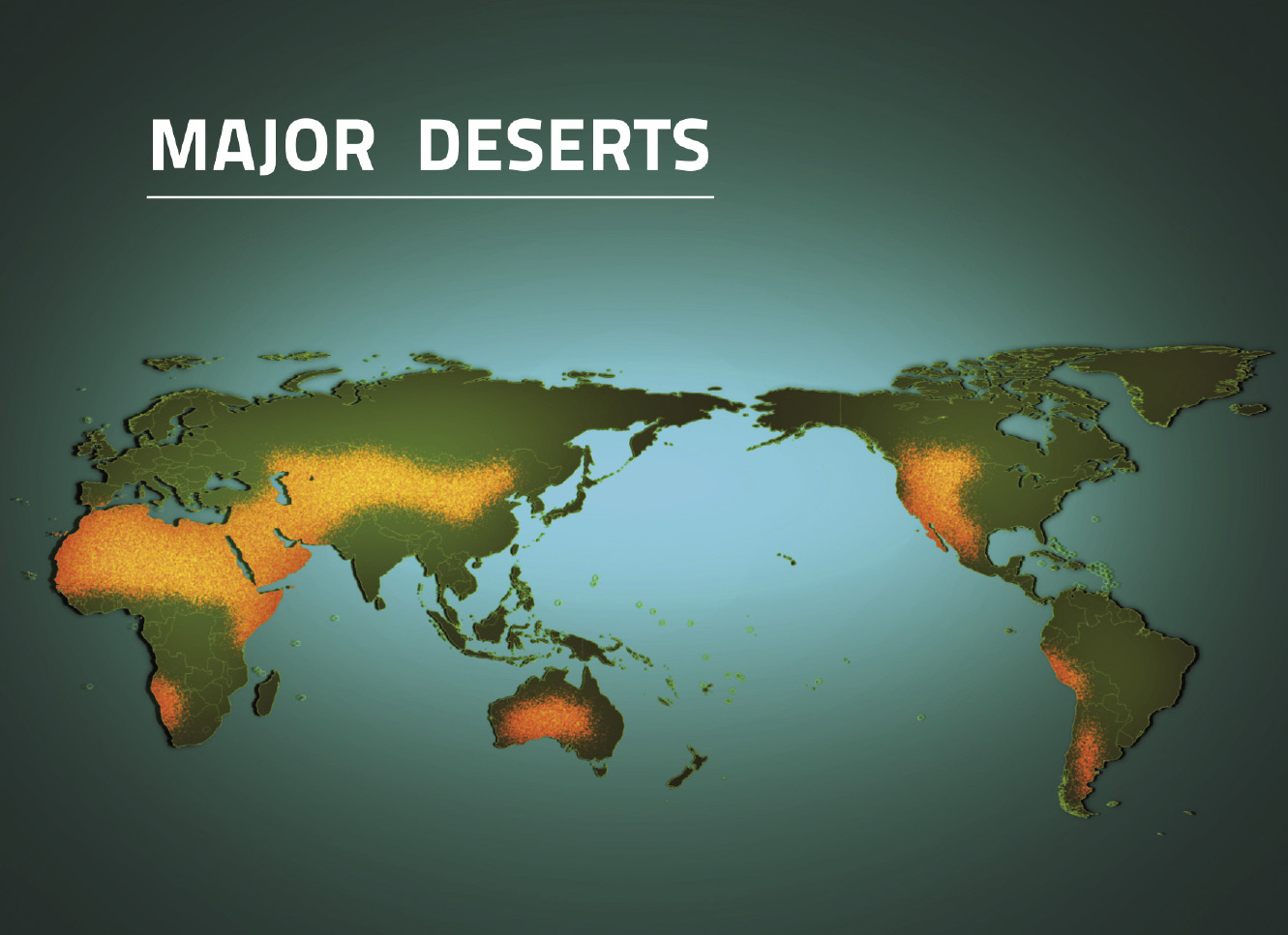
“This vast desert region can be considered an interconnected and continuous climate system, as each part affects the other. It stretches almost continuously from the Atlantic coast of North Africa through the Arabian Peninsula, across the Zagros Mountains to Iran and Central Asia, and all the way to western China, for about 13 million square kilometers. Large parts of those regions receive less than 250 mm/year, and often almost no precipitation. The semi-desert or semi-arid areas which are partly populated, receive 250-500 mm of annual rainfall.
“These deserts are, at the same time, expanding, not only due to the lack of adequate measures, but also the political destabilization and wars.”
But this process can begin to be reversed by the progress of science and application of existing modern water technology. The key measures include:
• creating new water resources, such as desalinating seawater and brackish water, using nuclear power;
• river diversion schemes, among the most important of which are the Transaqua Plan—in which the Vatican has been involved—for replenishing Lake Chad through diverting a portion of the extraordinarily large flow of the Congo River;
• developing the infrastructure systems in the existing river basins, such as the Nile, Tigris, and Euphrates, to make the maximum use of the water and reduce waste of it;
• better management of the existing vast groundwater potential;
• development of new methods and technologies for agriculture and irrigation, both to expand the green cover in the desert areas, to improve the traditional agriculture in the river basin areas, and to expand groundwater-fed desert agriculture with effective irrigation systems and reduction of the salinity of the soil.
These, Askary says, are one integrated approach.
Desalination and Nuclear Power
More than two-thirds of the world’s production of freshwater by desalination occurs in Southwest Asia, specifically in the Persian Gulf. Saudi Arabia alone produces 25 million cubic meters of water per day, which is estimated to be one-half of the world’s total. The United Arab Emirates (UAE) produces around 3 million cubic meters per day. However, these countries will have to more than double the amount of desalinated water in the next decade, and triple it in the decade beyond. Water consumption will rise from 8 billion cubic meters in 2012 to about 11 billion cubic meters in 2016. Massive investments are already projected in this area.
A major problem in these projections is that the desalination of seawater is reliant on thermal power plants run by oil and gas. Saudi Arabia, for example, uses 1.5 million barrels of oil daily to produce the electricity and heat used for desalination. So, tripling and quadrupling that amount of fuel is a major economic and environmental problem.
One of the key solutions to this problem is to use nuclear power for these purposes, and to use fossil fuels as chemical feedstocks. According to the International Atomic Energy Agency’s studies, medium-sized nuclear reactors are suitable for desalination.
At the moment, Iran is the only country in the region which has an operating large civilian nuclear power plant. The Bushehr plant, which is a product of cooperation between Iran and Russia, was inaugurated officially in September 2011, and reached its full capacity of power production (1,000 megawatts) in August 2012. Iran is planning to build several new nuclear reactors, with the expressed aim of increasing the energy output of the country and desalinating seawater.
The UAE, through a contract with South Korean Korea Electric Power Corporation (Kepco) is building four 1,400 MW nuclear plants to be completed by by 2020.
Egypt signed an agreement with the Russian atomic energy corporation Rosatom in February, to build the first of a number of nuclear power plants along the western Mediterranean coast of Egypt at El-Dabaa. The expressed objective is to use the power for seawater desalination in that remote and dry area of the country, where almost no freshwater exists in sufficient amounts to sustain an urban and industrial center. If successful, Egypt will continue to use the nuclear technology in the Red Sea region too.
Expanding the Desert Cover
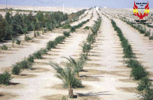
A great deal of research has been done and is continuing in many countries, Askary reports, to develop new strains and types of crops and plants that are resistant to the high temperatures in these regions and to the increasing salinity of the soil. One type can be planted near existing rivers, canals, and abundant groundwater. These are fruit-bearing trees such as palms, olive trees, eucalyptus, and tamarind trees, for example. These are highly resistant to heat and salinity, but they still need large amounts of water.
Therefore, they are planted, as proposed by many governments, closer to existing water resources and and urban infrastructure systems, because they need a labor force to manage them, and power and water infrastructure to sustain that. These can be used as a barrier to protect the existing agriculture and urban centers against the encroachment of the desert and the frequent sand and dust storms. These, then, can be expanded in the form of “green belts” outwards against the larger desert. In certain areas where there are saline lakes or saline groundwater, such as in western Iraq or Algeria, halophytes can be planted to create another green cover for moderating the air temperature and increasing the moisture in the atmosphere.
The farther you go into the desert, the more you will be challenged by lack of water and infrastructure. Therefore, there are active plans, although on a limited scale, to plant certain types of plants or shrubs that are extremely resistant to drought, and can be sustained on a limited amount of water or even on the scarce natural rainfall. These would a first line of resistance against the desert. These plants can be supported by “dune fixation,” or soil-stabilizing structures using dry plants or artificially produced materials such as plastics.
Then there is the development of irrigation techniques. Submerging the crops, the traditional method, leads to enormous waste of water through evaporation, and to increased salinity left behind by the evaporated water. Therefore, this is being abandoned in many parts of these desert regions. It is being replaced by pivot-sprinkler systems and drip irrigation, so that only a minimal amount of water is administered to the roots of the plants through plastic-tube systems.
The most advanced centers for the development of these sorts of techniques are in countries that suffer from desertification, but that are equipped with technological and industrial know-how. An example is China’s Ningxia Academy of Agriculture and Forestry Sciences in China, where many experts from Arab countries are trained, and the Jacob Blaustein Institute for Desert Research at Ben Gurion University in the Negev Desert in Israel.
Space Technology
The crucial question is whether there are possibilities of managing weather change in this vast arid area, and by what means.
Askary has discussed this with Egyptian and other experts. “Left to the raw powers of Nature,” he says, “these regions will be subjected to recurring cycles of droughts and wet periods. However, with the creative intervention of human labor, gradual changes can be made to moderate, and finally control the climate systems.”
The scientific frontier work for this purpose, is electrical ionization of the atmosphere—essentially using ground-based electrically powered ionization of the low atmosphere, to cause the formation of low cloud cover somewhat in the same way that cosmic rays from the galaxy have been shown to do. Two of the countries in which experiments with such ionization have been underway, are in the region: Israel and the United Arab Emirates.
Askary notes that “All the infrastructure, agriculture, irrigation projects proposed in this issue of EIR will have a definite positive impact on these regions, but how much impact will depend on the scale and rapidity of action.
“One way of determining that is by using space technology to follow the moisture cycles on Earth from areas of vegetation to other areas, measuring the impact of precipitation [and learning] . . . where this moisture is migrating.
“Creating new green zones in or near the deserts will potentially have a similar impact, he said.”
This vast desert region stretches from the Atlantic coast of North Africa through the Arabian peninsula, across the Zagros Mountains to Iran and Central Asia, and all the way to western China.
This is a project in Iraq. Instead of just a few hundred meters, a greenbelt should be several kilometers wide. You have a shield of greenbelts, and you move against the desert.
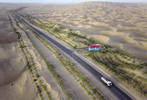
This is China, the Taklamakan Desert Highway. They wanted to protect the road from the moving sand. You pump water from underground: It’s salty water, but they have planted types of plants that resist salt.
Catastrophic Drought in Brazil Results From Decades of Policy Failures
by Dennis Small
April 11—If it weren’t so deadly, it would almost sound like a child’s riddle: What country has more water than any nation on the planet, yet is suffering the worst drought in nearly a century?
The answer is Brazil, one of the five members of the BRICS group of nations.
On top of the chronic water shortage that the country’s semi-arid Northeast region faces, drought has now struck with a vengeance in southeastern Brazil, the country’s most populous and industrialized region—including the 20 million people who live in Greater São Paulo, South America’s largest city. The drought is the worst recorded in the last 80-85 years. The rainy season, which is now coming to an end, has not significantly remedied a scarcity that is so bad, that São Paulo water officials are warning that they might soon decide to impose water rationing for as much as five of the seven days of the week.
São Paulo’s Cantareira reservoir/dam system, which is still the source of water for 6.5 million of its residents, in mid-March was at 11.9% of total capacity (including the reservoir’s “dead” or inactive storage). Large hospitals and water-intensive businesses—those that can—are installing in-house water treatment and recycling centers, and water trucks are proliferating around the city. But the poor do not have the resources to pay for water, and are going thirsty.
There are already reports that large numbers of slum-dwellers in the northern belt of São Paulo, who over the years migrated there largely from the impoverished Northeast, fleeing that area’s drought, are now so desperate that they are heading back to the Northeast. As in California, if the crisis is not reversed, it will not be long before we see virtual death marches of millions of hungry and thirsty people on a desperate quest for survival—the intended result of the British Empire’s policy of drastic depopulation of the planet.
Water, Water Everywhere . . .
The monstrous absurdity of this situation comes into sharper focus if we consider some elementary parameters of the global water cycle, and its expression in Brazil.
As we document elsewhere in this issue, of the enormous amounts of evaporation of seawater that the Sun continually produces, only 10% falls back down to Earth as precipitation over land. The rest simply rains back down into the oceans, to continue the cycle. To date, all of mankind’s advances in water management have concentrated on the 10% available on land. If we look at the planet as a whole, that 10% amounts to some 42,900 cubic kilometers per year of what international agencies such as the UN Food and Agriculture Organization (FAO) call Total Renewable Water Resources (TRWR). But mankind only withdraws, or utilizes, 9% of that amount globally. In other words, we are currently making use of less than 1% of what the biosphere, driven by the Sun, has made potentially available to us as freshwater! That clearly leaves a lot of room for improvement, if we master the science and technology needed to tap into the 99% that is currently out of reach—not to mention using nuclear desalination of seawater to add some of our own new water cycles to those that the biosphere is already providing.
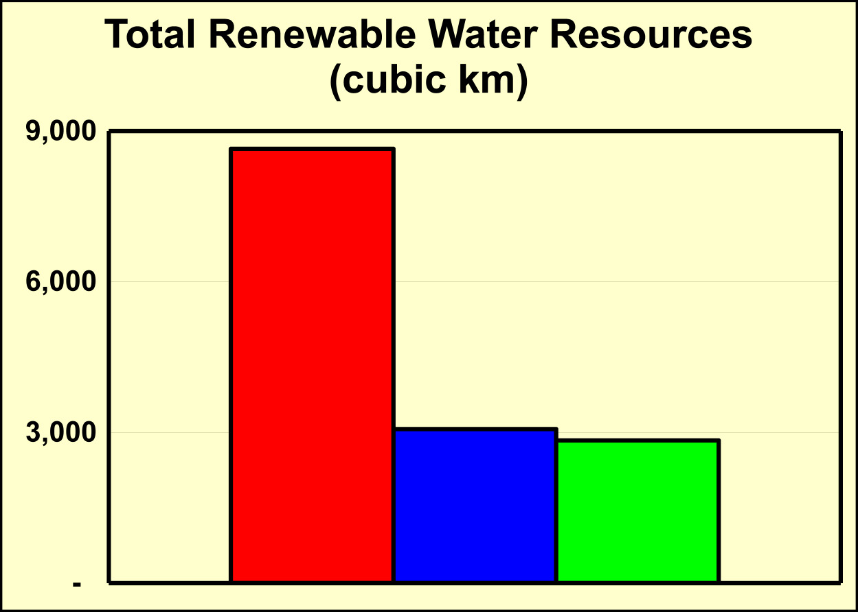
But in Brazil, the contrast is even starker than the planetary averages indicate. Brazil, with a population of 200 million, is home to fully one-fifth of the planet’s TRWR—8,600 cubic km per year—and three quarters of that comes from the Amazon River system. The Amazon is not only the longest river in the world; it has a rate of discharge at its mouth of 209,000 cubic meters of water per second, which is more than five times greater than the discharge volume of the world’s second largest river, the Congo (with 41,200 cubic meters per second).
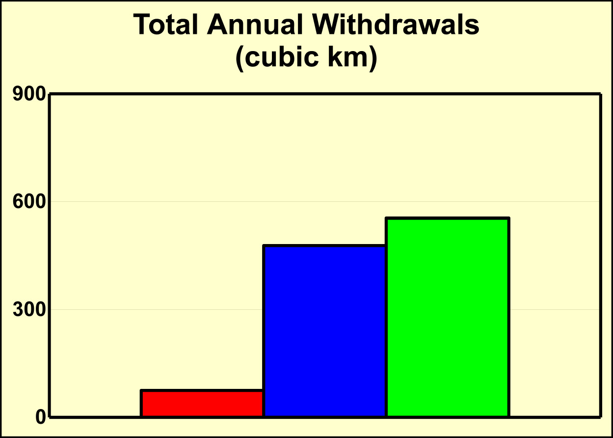
So Brazil, which in land mass is slightly larger than the continental United States, has almost three times the available freshwater that the U.S. has (Figure 1). But it withdraws or uses only about one-third as much as the U.S. does (Figure 2). Or, to put it even more starkly, if the planet as a whole is making use of less than 1% of the total freshwater that the biosphere is producing, day-in and day-out, Brazil is using an order of magnitude less than even that planetary average.
Why?
LaRouche’s Track Record in Brazil
“It’s their own damned fault,” Lyndon LaRouche recently commented when informed about the worsening drought in Brazil. “We warned them repeatedly, and outlined the solutions.”
For instance, in October 2001, LaRouche, then a candidate for the Democratic nomination for President for the 2004 elections, was invited to Brazil to address an international conference sponsored by the Brazilian Congress, on the subject of “Brazil and the Free Trade Agreement of the Americas.” Although the intervention of Prince Philip’s World Wildlife Fund (WWF) and other enemies of development led to LaRouche’s agreed-upon security arrangements being denied at the last minute, making it impossible for him to attend in person, LaRouche did send a written presentation to the conference on “The Future of Brazil’s Agriculture.” Therein, LaRouche stated:
“South America is a continent of vast, largely untapped natural resources. The principal obstacle to the physical development of those resources is the lack of basic economic infrastructure, in categories of transportation, power, and large-scale water management. The objective must be to define the continent as a unified Noösphere, which its inhabitants must manage. The objective of management is not to maintain the Biosphere in its present state, but to raise it to a relatively elevated state of health, which only mankind can do. . . . That is, in fact, Brazil’s only chance for survival as a nation. It is the only chance for that presently imperiled continent as a whole.”
Nine months later, Lyndon and Helga LaRouche were able to travel to Brazil, where they had extensive meetings with the country’s political and scientific elite, and Lyndon LaRouche was named an Honorary Citizen of São Paulo by the city’s authorities. In one high-level public exchange at a June 11, 2002 conference co-sponsored by the Alumni Association of the Superior War College (ADESG) and EIR, Lyndon LaRouche responded to comments made by roundtable participants Gen. Oswaldo Muniz Oliva, former director of the Superior War College, and Congressman Marcos Cintra, as follows:
“Now, you take a country like Brazil. Brazil has vast natural resources. . . . The future of Brazil lies in development of its potential resources, in management of its resources, including the vast water resources. The Amazon system is a vast resource, a vast power resource. It’s also probably more valuable as a resource for biological development, and transformation of the Biosphere, than it is as an energy source, because the long-term objective is to meet that kind of challenge. . . . The question of value lies in what the human mind is able to develop, which will transform man’s relationship to nature, in the sense of the Noösphere, and thus increase not only man’s condition in life; but if we can take the entire population and educate them on university levels to the age of 25, and shift our employment from low-technology to high-technology employment, and scientific employment, then we will have produced true value which our descendants will bless us for.”
It’s the Noösphere’s Turn
LaRouche’s policy recommendations registered in Brazil—but they were not acted on over the intervening dozen years, largely due to massive international pressure from the collapsing trans-Atlantic financial system and its hit-men, including in the Green movement, complemented by a specifically Brazilian penchant for foolhardy “pragmatism” and “not rocking the boat.” However, the world today has changed: As a member of the BRICS, and with the global leadership provided by China in the areas of water management and space sciences, Brazil is finally in a position to implement such policies. Among the great projects to be undertaken by Brazil, its South American neighbors, and the BRICS more broadly, are:
• First and foremost, develop entirely new science and technologies to gain access to the full water cycle. Brazil should participate fully in international research and demonstration projects involving atmospheric ionization, including research on solar and galactic factors in cloud formation, precipitation, and climate changes more generally. The enormous photosynthetic efficiency that the biosphere displays in the Amazon region, could prove a useful laboratory for man’s discovery of related universal physical principles.
To this end, Brazil has a significant aerospace sector which must be fully developed with its BRICS and other partners, including expanding Brazil’s Alcantara space launch center on the northern Atlantic coast—the closest launching base to the equator, which makes launches cheaper and more efficient than from other sites.
• Vastly expand nuclear energy production in Brazil, including for use in dozens of nuclear desalination plants to be built along Brazil’s extensive coastline. As noted above, nuclear desalination adds an entirely new, man-made freshwater cycle to what the Biosphere is already doing. Brazil currently has two functioning nuclear power plants, Angra I and Angra II, but they produce only 3% of the nation’s electricity. Fully 75% is now produced by hydroelectric plants, which is a massive vulnerability under conditions of drought such as those that Brazil is now experiencing. Because of the foolish failure to launch a crash nuclear program decades ago, the country now faces the nightmare scenario of the drought causing a shortage of both water and of electricity.
A proper policy would reverse the proportions, and have nuclear providing 70-75% of the country’s energy requirements, as it does in France, which would reduce Brazil’s dependence on hydroelectricity as well as make it possible to use nuclear for desalination.
• Interconnect the three great river systems of South America: the Amazon, the Orinoco, and the Rio de la Plata. This project, which dates back to Alexander von Humboldt’s proposals in the 19th Century, would allow for continuous inland water transportation connecting every nation of South America (with the exception of Chile), and also open up options for large-scale water transfers from the central Amazon basin to the southeast of Brazil and Argentina. This area is the continent’s scientific and industrial heartland, where every cubic meter of water consumed is far more productive, in terms of work performed, than a seemingly equivalent cubic meter of water in the Amazon.
• Complete the Great Waterway, an inland waterway already partially constructed, linking Brazil’s highly productive Cerrado savannah with Bolivia, Paraguay, Argentina, and Uruguay, on its way to the South Atlantic Ocean,
In short, Brazil is a place where the Biosphere is already doing a substantial amount of productive work. But it is high time for the Noösphere, man’s creative potential, to now do what it alone can do, beginning with policies and actions by the BRICS.